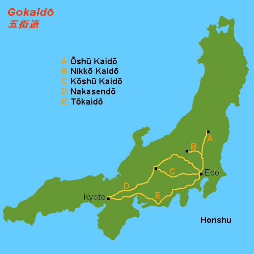
ŇĆshŇę KaidŇć on:
[Wikipedia]
[Google]
[Amazon]
 The was one of the five routes of the
YumekaidŇć. Accessed September 4, 2007. there were over 100 designated post stations when the subroutes are included.
 :Starting Location: Nihonbashi (śó•śú¨ś©č) ( ChŇęŇć-ku)
:1. Senju-shuku (ŚćɚŏŚģŅ) (
ŇĆshŇę KaidŇć Travel Journal
dead link] {{DEFAULTSORT:Oshu Kaido Road transport in Japan 17th-century establishments in Japan Japan-related lists
 The was one of the five routes of the
 Edo period
The or is the period between 1603 and 1867 in the history of Japan, when Japan was under the rule of the Tokugawa shogunate and the country's 300 regional '' daimyo''. Emerging from the chaos of the Sengoku period, the Edo period was characteriz ...
. It was built to connect Edo (modern-day Tokyo
Tokyo (; ja, śĚĪšļ¨, , ), officially the Tokyo Metropolis ( ja, śĚĪšļ¨ťÉĹ, label=none, ), is the capital and largest city of Japan. Formerly known as Edo, its metropolitan area () is the most populous in the world, with an estimated 37.468 ...
) with Mutsu Province and the present-day city of Shirakawa, Fukushima Prefecture, Japan
Japan ( ja, śó•śú¨, or , and formally , ''Nihonkoku'') is an island country in East Asia. It is situated in the northwest Pacific Ocean, and is bordered on the west by the Sea of Japan, while extending from the Sea of Okhotsk in the north ...
. It was established by Tokugawa Ieyasu
was the founder and first ''shŇćgun'' of the Tokugawa Shogunate of Japan, which ruled Japan from 1603 until the Meiji Restoration in 1868. He was one of the three "Great Unifiers" of Japan, along with his former lord Oda Nobunaga and fello ...
for government officials traveling through the area.
Subroutes
In addition to the established use of traveling from Edo to Mutsu Province, there were also many roads that connected from the ŇĆshŇę KaidŇć. One such sub-route was theSendaidŇć The was a subroute of the ŇĆshŇę KaidŇć, one of the Edo Five Routes of Japan. It connected the ŇĆshŇę KaidŇć's terminus in Shirakawa and Mutsu Province with Sendai. It was established by Tokugawa Ieyasu for government officials traveling through t ...
(šĽôŚŹįťĀď), which connected Mutsu Province with Sendai. The terminus for the SendaidŇć is in Aoba-ku in modern Sendai. From there, the MatsumaedŇć The was the continuation of the ŇĆshŇę KaidŇć, one of the Edo Five Routes of Japan. It connected the SendaidŇć's terminus at Sendai Castle with the northern tip of modern-day Aomori Prefecture. It was established by Tokugawa Ieyasu for governmen ...
(śĚĺŚČćťĀď) connected Sendai with Hakodate
is a city and port located in Oshima Subprefecture, Hokkaido, Japan. It is the capital city of Oshima Subprefecture. As of July 31, 2011, the city has an estimated population of 279,851 with 143,221 households, and a population density of 412.8 ...
, HokkaidŇć
is Japan's second largest island and comprises the largest and northernmost prefecture, making up its own region. The Tsugaru Strait separates HokkaidŇć from Honshu; the two islands are connected by the undersea railway Seikan Tunnel.
The la ...
. Though the ŇĆshŇę KaidŇć has only 27 post stations,ŇĆshŇę KaidŇć MapYumekaidŇć. Accessed September 4, 2007. there were over 100 designated post stations when the subroutes are included.
Travel
In the early Edo period, travel along the road mostly consisted of magistrates heading towards Edo in order to take part in '' sankin kŇćtai''. After Hakodate's development, the late Edo period saw travel further increase as a result of increasing trade withRussia
Russia (, , ), or the Russian Federation, is a List of transcontinental countries, transcontinental country spanning Eastern Europe and North Asia, Northern Asia. It is the List of countries and dependencies by area, largest country in the ...
.
Nowadays, the path of the ŇĆshŇę KaidŇć and its extensions is followed by National Route 4 from Tokyo to Aomori via Sendai and National Route 280 from Aomori to Minamya.
Stations of the ŇĆshŇę KaidŇć
The 27 stations of the ŇĆshŇę KaidŇć are listed below in order and are divided by their modern-day prefecture. The first seventeen stations are shared with theNikkŇć KaidŇć
The was one of the five routes of the Edo period and it was built to connect Edo (modern-day Tokyo) with the temple-shrine complex of the Mangan-ji and TŇćshŇćsha (now called the RinnŇć-ji and TŇćshŇćgŇę), which are located in the present-day ...
. The present day municipality is listed afterwards in parentheses.Tokyo
 :Starting Location: Nihonbashi (śó•śú¨ś©č) ( ChŇęŇć-ku)
:1. Senju-shuku (ŚćɚŏŚģŅ) (
:Starting Location: Nihonbashi (śó•śú¨ś©č) ( ChŇęŇć-ku)
:1. Senju-shuku (ŚćɚŏŚģŅ) (Adachi-ku
is a special ward located in Tokyo Metropolis, Japan. It is located to the north of the heart of Tokyo. The ward consists of two separate areas: a small strip of land between the Sumida River and Arakawa River and a larger area north of the A ...
)
Saitama Prefecture
:2. SŇćka-shuku (ŤćȌ䆌ģŅ) (SŇćka
is a city in Saitama Prefecture, Japan. , the city had an estimated population of 249,645 in 118,129 households and a population density of 9100 persons per km². The total area of the city is .
Geography
Situated in the southeast corner of Sa ...
)
:3. Koshigaya-shuku (Ť∂ä„É∂Ťį∑ŚģŅ) (Koshigaya
is a city located in Saitama Prefecture, Japan. , the city had an estimated population of 345,353 in 158,022 households and a population density of 5700 persons per km². The total area of the city is . It is famous for producing daruma dolls ...
)
:4. Kasukabe-shuku (Á≤ēŚ£ĀŚģŅ) ( Kasukabe)
:5. Sugito-shuku (śĚČśąłŚģŅ) ( Sugito, Kitakatsushika District)
:6. Satte-shuku (ŚĻłśČčŚģŅ) ( Satte)
:7. Kurihashi-shuku (ś†óś©čŚģŅ) ( Kuki)
Ibaraki Prefecture
:8. Nakada-shuku (šł≠ÁĒįŚģŅ) (Koga
KOGA is a Dutch bicycle manufacturer based in Heerenveen, Friesland. The company is known for its long time partnership with Japanese frame manufacturer Miyata, producing bicycles and sponsoring racing teams under the brand name Koga Miyata. As ...
)
:9. Koga-shuku (ŚŹ§ś≤≥ŚģŅ) (Koga)
Tochigi Prefecture
:10. Nogi-shuku (ťáéśú®ŚģŅ) ( Nogi, Shimotsuga District) :11. Mamada-shuku (ťĖď„ÄÖÁĒįŚģŅ) ( Oyama) :12. Oyama-shuku (ŚįŹŚĪĪŚģŅ) (Oyama) :13. Shinden-shuku (śĖįÁĒįŚģŅ) (Oyama) :14. Koganei-shuku (ŚįŹťáĎšļēŚģŅ) ( Shimotsuke) :15. Ishibashi-shuku (Áü≥ś©čŚģŅ) (Shimotsuke) :16. Suzumenomiya-shuku (ťõÄŚģģŚģŅ) (Utsunomiya
is the prefectural capital city of Tochigi Prefecture in the northern KantŇć region of Japan. , the city had an estimated population of 519,223, and a population density of . The total area of the city is . Utsunomiya is famous for its '' gyoza' ...
)
:17. Utsunomiya-shuku (ŚģáťÉĹŚģģŚģŅ) (Utsunomiya)
:18. Shirosawa-shuku (ÁôŜ姌ģŅ) (Utsunomiya)
:19. Ujiie-shuku (śįŹŚģ∂ŚģŅ) ( Sakura)
:20. Kitsuregawa-shuku (ŚĖúťÄ£Ś∑ĚŚģŅ) (Sakura)
:21. Sakuyama-shuku (šĹźšĻÖŚĪĪŚģŅ) (ŇĆtawara
270px, View from the ruins of ŇĆtawara Castle
is a city located in Tochigi Prefecture, Japan. , the city had an estimated population of 72,189 in 30,136 households, and a population density of 210 persons per km2. The total area of the city is ...
)
:*Yagisawa-shuku (ŚÖęśú®ś≤ĘŚģŅ) (ŇĆtawara) ('' ai no shuku'')
:22. ŇĆtawara-shuku (Ś§ßÁĒįŚéüŚģŅ) (ŇĆtawara)
:23. Nabekake-shuku (ťćčśéõŚģŅ) (Nasushiobara
270px, Shiobara Onsen
is a city located in Tochigi Prefecture, Japan. , the city had an estimated population of 115,794 in 48,437 households, and a population density of 67 persons per km². The total area of the city is .
Geography
Nasushioba ...
)
:24. Koebori-shuku (Ť∂䌆ČģŅ) (Nasushiobara)
:*Terago-shuku (ŚĮļŚ≠źŚģŅ) (Nasushiobara) (''ai no shuku'')
:25. Ashino-shuku (Ťä¶ťáéŚģŅ) ( Nasu, Nasu District)
:*Tani-shuku (Ťį∑ŚģŅ) (Nasu, Nasu District) (''ai no shuku'')
:*Yorii-shuku (ŚĮĄŚĪÖŚģŅ) (Nasu, Nasu District) (''ai no shuku'')
Fukushima Prefecture
:26. Shirosaka-shuku (ÁôĹŚĚāŚģŅ) ( Shirakawa) :27. Shirakawa-shuku (ÁôĹŚ∑ĚŚģŅ) (Shirakawa) :Ending Location:Shirakawa Castle
is a Japanese castle located in what is now the city of Shirakawa, southern Fukushima Prefecture, Japan. Throughout the middle to later Edo period, Komine Castle was home to the Abe clan, ''daimyŇć'' of Shirakawa Domain. It was also referred to ...
(ÁôĹś≤≥Śüé) (Shirakawa)
See also
*Edo Five Routes
The , sometimes translated as "Five Highways", were the five centrally administered routes, or ''kaidŇć'', that connected the ''de facto'' capital of Japan at Edo (now Tokyo) with the outer provinces during the Edo period (1603‚Äď1868). The most ...
** TŇćkaidŇć (or 53 Stations of the TŇćkaidŇć)
**NakasendŇć
The , also called the ,Richard Lane, ''Images from the Floating World'' (1978) Chartwell, Secaucus ; pg. 285 was one of the five routes of the Edo period, and one of the two that connected Edo (modern-day Tokyo) to Kyoto in Japan. There were 69 ...
(or 69 Stations of the NakasendŇć
The are the rest areas along the NakasendŇć, which ran from Nihonbashi in Edo (modern-day Tokyo) to SanjŇć ŇĆhashi in Kyoto.Yama to Keikoku Publishing (2006). NakasendŇć o Aruku (Revised ed.). Osaka: Yama to Keikoku Publishing. .KŇćshŇę KaidŇć
The was one of the five routes of the Edo period. It was built to connect Edo (modern-day Tokyo) with Kai Province in modern-day Yamanashi Prefecture, Japan. The route continues from there to connect with the NakasendŇć's Shimosuwa-shuku in ...
**NikkŇć KaidŇć
The was one of the five routes of the Edo period and it was built to connect Edo (modern-day Tokyo) with the temple-shrine complex of the Mangan-ji and TŇćshŇćsha (now called the RinnŇć-ji and TŇćshŇćgŇę), which are located in the present-day ...
*Other routes
**Hokkoku KaidŇć
The was a highway in Japan during the Edo period. It was a secondary route, ranked below the Edo Five Routes in importance. Because it was developed for travelers going to ZenkŇć-ji, it was also called ''ZenkŇć-ji KaidŇć'' (ŚĖĄŚÖČŚĮļŤ°óťĀď). It st ...
**Kisoji The was an old trade route in the Kiso Valley that stretched from Niekawa-juku in Nagano Prefecture to Magome-juku in Gifu Prefecture. There were eleven resting spots along the route, all of which became part of the NakasendŇć when it was establ ...
**Mikuni KaidŇć was an ancient highway in Japan that stretched from Takasaki-juku (present day Gunma Prefecture) on the NakasendŇć to Teradomari-juku (present day Niigata Prefecture) on the HokurikudŇć.
History
The Mikuni Pass separated the KantŇć region from Ech ...
** Tanabu KaidŇć
References
External links
ŇĆshŇę KaidŇć Travel Journal
dead link] {{DEFAULTSORT:Oshu Kaido Road transport in Japan 17th-century establishments in Japan Japan-related lists